Posts

Showing posts from August, 2018

Is the indoor air quality at Thompson Rivers University in Kamloops safe?

Image
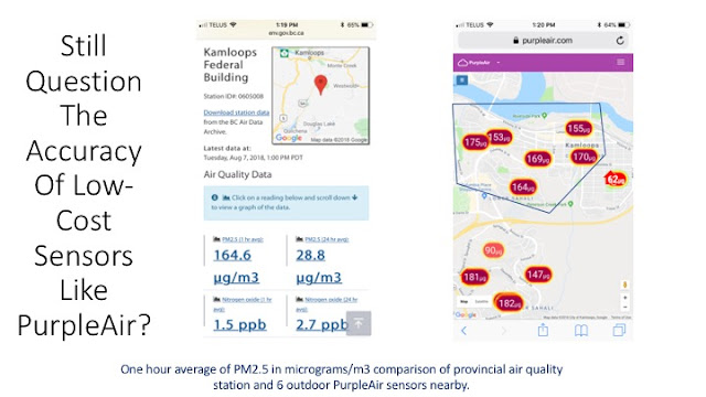
Forest fire activity in the Province of British Columbia and elsewhere during the Summer of 2018 has once again raised concerns about air quality and human health impacts. Although the Summer of 2017 had longer and more intense wood smoke pollution events in communities like Kamloops then this year, this Summer has seen larger spikes in pollution. For a comparison of the two summers and for a discussion on the implications of multiple years of smoke exposure, click here . On August 23, 2018, smoke in the City of Kamloops returned with a vengeance. The provincial air monitoring station at the Federal Building in downtown Kamloops recorded a one hour average for PM2.5 of 231.1 micrograms/m3 at 10PM. Our PurpleAir network showed almost exactly the same levels across the "swarm" of low-cost sensors setup in the city. To learn more about how this technology compares to expensive government monitoring stations, click here . Additional examples comparing the network to sa

A "swarm" of low-cost sensors showing differences in air quality

Image
Just as quickly as the air pollution tanked into the hazarous zone this past week, it has rebounded over the past few hours. Here's an example from our network of PurpleAir sensors on Gabriola Island of this rapid improvement, and escape (perhaps temporarily) from the forest fire woodsmoke blanketing much of the province. Is the air quality on Gabriola Island good right now? It depends on where you are. Note the air pollution stratification with parallel poor readings on Vancouver Island. This is only a difference of around 5km (North to South).

How does the Summer of 2017 compare to this Summer so far?

Image
While much of BC is blanketed with wood smoke from forest fires raging across the province and elsewhere, there are some parts of the province that have been hit with bad air pollution more than others. This is due in part to terrain, proximity to forest fires, and other factors. Although our network of PurpleAir sensors is rapidly expanding across the province, the highest concentration is currently in the Kamloops area. Kamloops has had two back-to-back bad summers with smoke affecting the community. How does the Summer of 2017 compare to this Summer? Below are graphs from two of our many PurpleAir sensors in Kamloops dating from July 1, 2017 to August 22, 2018. We have selected one sensor at an intermediate elevation in the city (Hugh Allan Drive) and one at a lower elevation (Moody Ave) to show you some trends. The data is based on 24-hour averages, and it's worth noting that the provincial 24-hour average target for PM2.5 is 25 micrograms/m3. We believe that this t

Why is our provincial government and local health authorities downplaying the risks associated with PM2.5 exposure?

In the August 15, 2018 issue of Kamloops Info News , it was suggested that exposure to PM2.5 from forest fires isn't a big deal and that the kind of air pollution generated by it is somehow less dangerous than exposure to smog found in larger cities. Although the amount of fine particulates currently in the air is comparable to large metropolitan cities with air quality problems, Ayache says the fine particulates in the Kamloops and the Okanagan are largely a result of the forest fires and don't contain a multitude of toxins you would find in a smog filled city. ( B.C. Ministry of Environment air quality meteorologist Tarek Ayache). This is complete and utter nonsense. PM2.5 from combustion of biomass (forest fires, wood stoves, biomass-based energy systems etc) contains hundreds of toxic chemicals that are bound to the surface of particulates. Many of these are highly carcinogenic and create acute responses including heart attacks and strokes. They have also been found to

Comparing graphs of air pollution in Kamloops - Provincial monitor versus PurpleAir

Image
The low-cost PurpleAir network acts like a "swarm" to provide more detailed data - at various locations - on air quality. The strength of this approach is to use all sensors in a region to understand more fully how air quality varies by elevation, proximity to a pollution source, and other factors. It's also very helpful to have multiple readings from independent devices. Here's another example of how the technology compares to the provincial air quality monitoring program. This example is a snapshot of several days of averaged data which compares the provincial monitor in Kamloops to the closest PurpleAir sensor. Note how the trend lines track each other.

How to control your exposure to wood smoke during forest fire events

Image
People sometimes take a laid-back approach to air pollution and often underestimate how both short term and long term exposures add up to health risks that can be serious. Heart attacks and strokes are much more common during high pollution days (and immediately afterwards), and particulate matter at the 2.5 micron scale (PM2.5) can accumulate in our blood stream and move into various organ systems causing damage from oxidative stress, inflammation, and other processes. With forest fires and ambient air pollution generated from non-point sources, there's sometimes a perception that nothing can be done to minimize exposure and that we should just get on with things. We sometimes hear comments like, "There's nothing we can do about it." The most important and successful way to reduce exposure to forest fire smoke is to stay indoors as much as possible, close windows, and to use air purifiers with HEPA 5-stage filtration. Here is some data from today on the ef

Still doubt the accuracy of low cost air quality monitors?

Image
Today, local forest fire events have triggered extremely high air quality readings in Kamloops BC. For more than two years the BC Ministry of Environment and others have been raising doubts about the quality and accuracy of citizen science networks like PurpleAir. They have issued statements to media, city councils, and other branches of government calling this equipment cheap smoke detectors that are Made in China. It's an inconvenient truth for them when smoke problems catch them with their pants down. Today the Air Quality Health Index lagged several hours in telling people in the community about the real risk. They had their index at a low risk level of 3 out of 10 when it was clear from our readings beginning at 3AM that this was a dramatic underestimate. The same thing happened all of last Summer in the region with incredibly high levels of risk to the population that were systematically downplayed. Here's (yet again) proof that these devices work - and they work